Prepare for Severe Weather: What to Expect Tonight and Tomorrow in Oneida
- edu.plus.weatherray Rome
- May 4
- 3 min read

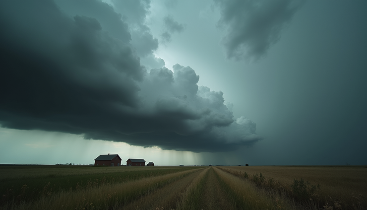
A powerful weather system is moving into the Oneida region, bringing a significant risk of severe thunderstorms overnight and through tomorrow. While isolated evening showers may seem minor, they are just the start of a much larger and more dangerous weather event. Residents of Madison County and surrounding areas should prepare for large hail, damaging wind gusts, flash flooding, and even the possibility of tornadoes. This post breaks down what to expect, how to stay safe, and what actions to take as the storm approaches.
Evening Weather Conditions
Tonight’s weather begins with isolated showers developing through the evening hours. These showers will be scattered and not widespread, so it won’t be a complete washout. Temperatures will climb into the lower 80s, accompanied by breezy conditions. While the rain may be light at first, it’s important to keep an eye on the sky as conditions will change quickly.
The evening is a good time to review your emergency plans and ensure you have access to weather alerts. Since winds will start picking up, secure any loose outdoor items that could become projectiles in stronger gusts later.
Overnight Storm Intensification
As the night progresses, showers will increase in intensity and coverage. Thunderstorms will become more frequent, with some storms reaching strong or severe levels. Winds will pick up significantly overnight, with gusts increasing and temperatures remaining warm, holding steady in the upper 80s to near 90°F.
This warm, moist air will fuel the storms, making them more intense and capable of producing damaging weather. Power outages are possible due to strong winds knocking down trees and power lines. Flash flooding risk will also rise as heavy rain falls over short periods.
Main Severe Weather Threat Tomorrow
Tomorrow brings the highest risk of severe weather for Oneida and Madison County. The storm system will unleash multiple hazards that could impact safety and property:
Large Hail
Hailstones could grow large enough to damage vehicles, roofs, and windows. Take care to move cars into garages or covered areas if possible.
Damaging Wind Gusts
Winds between 50 and 60 mph may down trees, power lines, and cause structural damage. Stay indoors and away from windows during storms.
Flash Flooding
Heavy rain rates could cause rapid flooding, especially in low-lying areas and places with poor drainage. Avoid driving through flooded roads—remember, turn around, don’t drown.
Tornadoes
While isolated, tornado development cannot be ruled out. Have a safe shelter plan ready and monitor weather alerts closely.
Heavy Rain
Widespread rainfall totals could be significant, adding to the flood risk and complicating travel and outdoor activities.

How to Stay Safe and Prepared
Severe weather can escalate quickly, so preparation is key. Here are practical steps to protect yourself and your family:
Receive Weather Alerts
Use multiple sources such as phone alerts, NOAA Weather Radio, and local news to stay informed of warnings and updates.
Avoid Flood-Prone Roads
Do not attempt to drive through flooded areas. Even a few inches of water can sweep a vehicle away.
Secure Outdoor Items
Bring in or tie down outdoor furniture, trash cans, and anything else that could blow away or cause damage.
Know Your Safe Shelter
Identify the safest place in your home, such as a basement or interior room without windows, where you can take shelter if a tornado warning is issued.
Prepare Emergency Supplies
Have essentials ready including water, food, flashlights, batteries, and a first aid kit.
Stay Updated
Follow local weather updates from trusted sources like OYNC News. The meteorology team will provide live coverage as the storm approaches.

Final Thoughts
The severe weather threat for Oneida and Madison County is serious and demands attention. While isolated showers this evening may seem harmless, they are the prelude to a night and day of potentially dangerous storms. Large hail, damaging winds, flash flooding, and tornadoes are all possible, so take the warnings seriously.


Comments